


sentier botanique de la plagne

lecmic
User
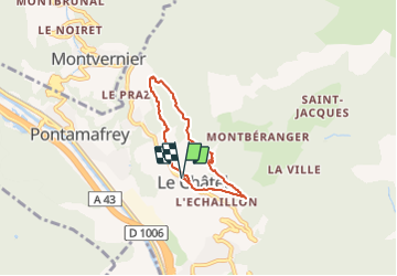

Length
5.3 km

Max alt
1038 m

Uphill gradient
271 m
Km-Effort
9 km

Min alt
769 m

Downhill gradient
270 m
Boucle
Yes
Creation date :
2019-09-16 05:52:12.787
Updated on :
2019-09-16 07:19:32.045
1h25
Difficulty : Very easy

FREE GPS app for hiking
 SityTrail
IGN / Geographical institutes
SityTrail Plus
The world is yours!
About
Trail Walking of 5.3 km to be discovered at Auvergne-Rhône-Alpes, Savoy, La Tour-en-Maurienne. This trail is proposed by lecmic.
Description
rando facile
Positioning
Country:
France
Region :
Auvergne-Rhône-Alpes
Department/Province :
Savoy
Municipality :
La Tour-en-Maurienne
Location:
Unknown
Start:(Dec)
Start:(UTM)
292852 ; 5020531 (32T) N.
Comments